Images provided by: Pam Kenway
Calling all bird watchers! Prepare to embark on an exciting bird-watching adventure in the mesmerizing Clarence Valley in the Northern Rivers of New South Wales. This haven of lush landscapes and ancient rainforests serves as a haven for a diverse range of bird species. As the sun rises, a captivating symphony of wings takes centre stage, inviting bird enthusiasts and nature explorers to immerse themselves in the world of our regions feathered residents.
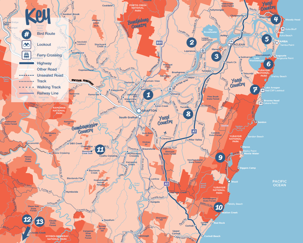
We extend a heartfelt thank you to the devoted members of the Clarence Valley Birdos, with special recognition to Pam Kenway, Jeanette Lawson, and Maureen O’Shea. Their dedication has led to the update of the original bird routes brochure from 2005, illuminating 12 enthralling bird-watching routes. With their guidance, we can now uncover hidden gems where both resident and migratory bird species thrive and flourish.
These 12 thoughtfully selected Bird Routes provide a wide range of opportunities for both birdwatchers and nature enthusiasts to enjoy and appreciate the beauty of the avian world. These routes traverse various coastal environments, stretching from the northern edges of Iluka down to the southern expanses of Station Creek. They also lead you through expansive wetlands in Ulmarra and Tucabia, allowing you to explore renowned National Parks such as Bundjalung and Yuraygir, and discover the beauty of numerous Nature Reserves scattered throughout the Clarence Valley.
While enjoying these routes, please remember to respect private property, avoid entering restricted areas, and always be mindful of where you park your car—safety first! Please don’t block driveways, farm entrances, or paddock gates, and help us ensure this natural paradise remains welcoming for all.
Clarence Valley Birdos go bird-watching on the third Saturday of each month (except December).
For details, please contact: Gary and Margaret Eggins mgeggins@gmail.com
A. Carrs Creek Bridge
Start at river end of Prince Street – Memorial Park. Take a stroll along the river before returning to set the trip meter.
Proceed along Prince St., turn left into Oliver St, right into Cranworth St., left into Fry St
then to railway crossing (3.6 km.) Park. Look for Peregrine Falcon in the windows of the old Peters’ factory.
Carrs Creek Bridge is just ahead- Tawny and Little Grassbirds, Australian Reed Warblers, Spotless Crake, Lewin’s Rail.
Walk across the bridge. Look in the paddocks- Richard’s Pipit.
Turn around, reset the trip meter, and take first left into Orara St, left into North St. and right -hand curve into Marlow St that becomes Back Lane. Turn right into Carrs Peninsula Rd (4.6km). At the junction with Summerland Way, turn left.
B. Corymbia Crown Reserve
Continue on past the Clarence Way turnoff on the left. Shortly after Orchard Rd on the left, enter the marked turning-left lane, turning off at letter box no. 1827. Enter the Corymbia Crown Reserve (29 34 10.34 S, 152 57 28.44E). Walk or drive/park along the Corymbia Fire Trail. After a short distance, the Corymbia Fire Trail veers to the left (terminating at a locked gate), and Wonabeena Trail continues straight ahead (terminating at a bridge indicating Private Property). Stop anywhere along the trails- Common Bronzewing, Fan-tailed Cuckoo, Little Lorikeet.
C. James Lane and Bunyip Creek
At Summerland Way, turn right back towards Grafton. Travel past the Clarence Way turn-off and turn left into Red Lane, right into Trenayr Rd. and left into Experimental Farm Rd. Note wetlands on left. Turn left into James Lane. Park near causeway on Bunyip Creek. -bush birds, Black Swans, Azure Kingfisher, White-breasted Woodswallow. Return, and turn left back onto Experimental Farm Rd.
Cross-over Alumy Creek, turn left at Lawrence Rd.
D. Strontian Park (picnic table, toilets) – 29.6410, 152.9982
Just before Tarrant Bridge turn Right into Great Marlow Road. Continue 2.1 km to Strontian Park on the river bank. A pleasant picnic spot. Check the adjacent drain No 2.- Azure Kingfisher, terns flying up river.
E. Southgate State Forest
Return to Lawrence Road. Just after crossing Tarrant Bridge turn left into School Lane. After 1.3 km there are wetlands on the right. At 3.7 km park on the opposite side of the road at properties no. 377 and no. 379. Here there are 3 options-
i. Walk along the power lines- there are bush birds on either side
ii. Enter gate no. 379 and walk about one km. This is a TSR- flood reserve- Speckled Warbler, Crested Shrike-tit, various honeyeaters, Pacific Baza, wrens.
iii. Continue to walk along School Lane through Southgate State Forest. Bush birds. Turn around at property no. 527.
Return along School Lane to Grafton-Lawrence Rd, turn left to Lawrence or right to Grafton.
F. The Washpen
From the Grafton bridge travel North along the big River Way, turning right into Swan Lane at about 5km. After 0.4 km on the gravel road, turn right into the un-named lane. Here you will have good views of the Washpen, a seasonal swamp on private land. Return to Swan Lane and continue to the end of the road where it intersects with Four Mile Lane (bitumen). There is a permanent swamp (waterhole?) on the left- Black Swan, Black-necked Stork various ducks and raptors.
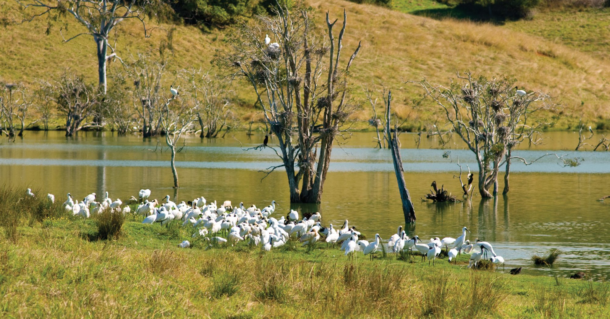
Return to Grafton via Four Mile Lane, right into Washpool Rd. Stop at the Service Station near big River Way and look across the road to the wetlands- Magpie Geese, Egrets, Ibis.
Turn left onto Big River Way, and return to Grafton.
G. Friars Lane
West of Grafton about 5 km along the Gwydir Highway, turn right into Friars’ Lane. An ephemeral wetland on the left, at times provides abundant birdlife. King Quail, Hoary-headed Grebe, Nankeen Kestrel.
Return to Gwydir Highway, turn right, drive over Cowan Creek Bridge and on the left is Cowan’s Pond Wetland Reserve. – picnic table, information board, and bird hide. May be overgrown. Water birds and bush birds.
The Egret Rookery
Proceed to Lawrence. From the Ferry proceed to the Egret Rookery- corner of Manton’s Lane and Rutland St. Egrets and waterbirds.
Opposite the Post Office (Rutland St) -picnic table, and a rough track along the river. Water birds rest on the old swimming pool posts.
Continuing on Rutland St, turn right into (Richmond St that then becomes) Pringles Way.
Manton’s Road & Imeson’s Swamp
At 3 km, turn left into Manton’s Road- swamp on both sides. Continue to the end of the road. Look down across Imeson’s Swamp – a scope is useful. Return to Lawrence.
Memorial Park
On the riverbank, opposite the shop and service station at Lawrence, Memorial Park offers covered picnic tables, boat ramp, children’s playground. Toilets are opposite and next to the Memorial Hall.
Everlasting Swamp National Park
Cross over Sportsman’s Creek Bridge, and turn right into Weir Road. Observe birds along the road, at the weir and then at the Everlasting Swamp N.P. Along the way, close any gates that need to be opened as part of the road is shared by local farmers. Drive into the park as far as possible.
Riverbank Road
Return along Weir Rd, turn right at Lawrence Rd, then immediatley left into Riverbank Rd, continue on this picturesque drive along the river to the inter-section with the Lawrence-Grafton Rd. Brolga, White-bellied Sea-Eagle.
Turn Right to Lawrence, or left to Grafton.
From McLachlan Park, Maclean, travel south through the CBD on River St, that becomes Cameron Street, turn right at the sign to Ilarwill-Lawrence, crossing the McFarlane Bridge onto Woodford Island, and continue on Lawrence Road.
About 1 km from the bridge stop at the Ilarwill Quarry on the left. – a Peregrine Falcon nests on the cliff face. Return to the McFarlane Bridge and turn right into South Arm Road. Follow this road for 17 km, then turn right into Red Hill Rd. The road finishes at Woodford Island Nature Reserve, a remnant rainforest. There are three main trails through the reserve, providing three possible walking circuits. Return to South Arm Rd. and turn right, noting the wetlands on the right – a scope would be useful. Continue to the next T-intersection, turning right onto Roberts Creek Rd.- water birds, though creek can be dry. Follow this road till it intersects with Lawrence Rd- turn right back to Maclean, or left to The Bluff Point Ferry, then to Lawrence.
OR
From Grafton, travel north along Big River Way. Turn left to Brushgrove crossing the Wingfield Bridge. Turn right into Clarence Street that becomes South Arm School Road. Continue until T-intersection with South Arm Rd., turn right then first left into Red Hill Rd which ends at Woodford Island Nature Reserve.
From Harwood Bridge travel north to the Iluka turn-off (enter the ramp, then the roundabout).
Proceed through Woombah village, then after about 3 km find the obscured turn-off on the left just past the 100km speed sign, into the Bundjalung Wilderness Area, Woombah East Trail. There is limited parking, and no facilities, but worth the visit. Tawny-crowned Honeyeater, Lewins Rail, Southern Emu-wren, Powerful Owl. A little further on, is Bill Weiley Bridge over the Esk River.
Continue to Shark Bay (4 km) [waders, seabirds and bushbirds]; to Woody Head Camping Area (1.0 km) [waders on rock platform south, bush birds on road in]- facilities and picnic areas; to Back Beach [bush birds in car park, waders on beach]; to Frazers Reef (2.0km) [bush birds and waders].
Returning to Iluka Road, enter Johnsons Lane at the northern end of the golf course. Proceed to river, (structure with Osprey nest), then turn right. At the end of gravel road is the Old Ferry Crossing, with parking and picnic area, but no facilities [bush and water birds]. Return to Iluka Road, turn right and next left to Iluka Bluff (1.5km)- facilities, parking and covered picnic tables; Bluff Beach [waders on rock platform; seabirds and whales (when migrating north or south) from Iluka Bluff Lookout, and Headland Walk to Iluka Beach]; and Iluka Rainforest Walk in the Iluka Nature Reserve [bush and rainforest birds, inc. Regent Bowerbird, White-eared Monarch and Rose-crowned Fruit-Dove – 5 km return]. Alternative entry to Iluka Rainforest Walk is via Spenser Street and Long Street in Iluka.
Continue to the village of Iluka (2.0 km -Sedgers Reef Hotel area for picnic or pub lunch).
Follow the pathway that follows the river from the Fisherman’s Co-op, past the Old Terminal Wharf (only concrete piers remaining) to Moriarty’s Wall – bush birds and water birds. Iluka Beach (end of Queen Street) and the break wall, also provide good birding
Shores Drive – No facilities.
From Harwood Bridge travel 14 km east along Yamba Rd. Approximately 1 km past the shopping fair turn left into Shores Drive, and continue to the end of the bitumen- Peninsular Park. A track on the right side of the park goes through mangrove and literal rainforest (Clarence Estuary Nature Reserve) – good early morning birding. On the left side of the park, walk along the dirt track (public reserve) that leads in front of the riverside houses. Look across to the sand bar and to Rabbit Island -shorebirds.
Hickey Island – toilets, picnic tables.
Return to Yamba Road that becomes Wooli Street . Just past the Bowling Club turn left into River Street (goes to Yamba Wharf) and then right into Harbour Street. Continue to the end of the caravan park, turn sharp left into the Hickey Island car park. Walk along the track that leads from the western end of the car park, to the end of the island. – mangrove and bush birds including Mangrove Honeyeater, waders. Pied Oystercatcher and Beach Stone-curlew (both endangered) are known to breed in this area.
James Creek Road – No facilities
Return along Yamba Rd. Just before the Harwood Bridge turn left into James Creek Rd. Stop at the wetland next to the Concrete Works. Good views of egrets, cormorants, darters, spoonbills, dotterels. Often raptors overhead.
From the Angourie Roundabout in Yamba, turn right along Angourie Road. After 4 km turn right on Lakes Blvd towards Wooloweyah, then left after 0.4 km onto the gravel road that goes to Angourie Point (1.9km) and Mara Creek (2.1km). Good birding is found along this road. Turn right to Mara Creek Car Park and Picnic Area. From here the Yuraygir Coastal Walk takes you to Dirrangan Lookout (2.5 km) and Shelley Headland (4.5km). Yellow-faced Honeyeater, Eastern Spinebill, White-naped Honeyeater, Silvereye, Noisy and Little Friarbird, Brown Quail, Swamp Harrier, White-bellied Sea-Eagle, Brown Goshawk, Brahminy Kite, Black-shouldered Kite, Wedge-tailed Eagle. A detour to Angourie Point and Angourie Pools is also worthwhile. Return to Lakes Boulevard and turn left towards Wooloweyah. Staying on Lakes Blvd, pass through the village to find the Foreshore Reserve, a good access area to the lagoon. Scaly-breasted Lorikeets, Pied and Little Pied Cormorants, Azure Kingfisher, Noisy Friarbirds, Eastern Osprey, Tawny Frogmouth.
From McLachlan Park, Maclean, drive west along Cameron Street and follow the signs to Brooms Head along Brooms Head Road. Emus have been seen on this road- take care.
Proceed into Brooms Head and turn left off the main Street (Ocean Road) near the caravan park office.
Stop on the lower beach front road -toilets, kiosk and picnic shelter.
At the southern end of the beach, there is a rock platform- waders, shorebirds and migratory birds Oct- March. Climb the steps, or drive via the road, to the headland lookout. A stop at Hibiscus Avenue when driving through Brooms Head can also prove fruitful.
Before leaving Brooms Head, turn left into Heath St and through the gate to the football ground. Walk across the sports ground to the wetlands- migratory waders. Return to Ocean Road, and after crossing the bridge over the sea entrance to Cakora Lagoon, stop at the bowling club to check out the Lagoon and Main Beach.
Continuing north, turn left onto the Sandon River Road (gravel), to Sandon. After 3 km turn into Bosches Waterhole Rd, second track on the right. Drive/walk through heathland to the Needlebark trees- 4 WD required after this point- Southern Emu-wren, Tawny-crowned Honeyeater, Ground Parrot. Return to Sandon Road and continue to Sandon (a pleasant picnic area, toilets) -waders and seabirds, Beach Stone-Curlew.
Head back to Brooms Head Road, turn left and continue to the turn-off to Yuraygir National Park, Lake Arragan and Red Cliff Campgrounds, stopping at the Electricity Substation on the way in. Turn right and bird/drive along Red Cliff Road -Tawny-crowned Honeyeater, Southern emu-wren, raptors, – to the picnic Area (Toilets and picnic tables). Bird around the picnic area, and the lake’s edge. Walk to the beach, cross over where the lake exits to the sea, and bird along the Shelley Track.
From Grafton, drive north on the Big River Way- turning right into Swan Lane. At the cattle yards turn right. There is a seasonal swamp known as “The Washpen”. This is private land, but there is good viewing from the road. Continue on Swan Lane, until it meets Four Mile Lane and turn left and park. Here there is a permanent water hole (Swan Lagoon). Black-necked Stork (could be nesting in tall gums- May till August), Black Swans, egrets, cormorants, ducks. In the grasses Golden-headed Cisticola, Tawny Grassbirds, Brown Quail and raptors can be found. Cross the Wilcox Bridge. Check out Lake Road on the right, return and continue along Four Mile Lane. Turn right into Finlaysons Road, right into Fullers Rd, and a sharp right into Deep Creek Rd. Turn right into Possum Hole Lane, then turn right into Coldstream Road. At the entrance to the town, Tucabia Flora Reserve is a must for bush birds (flycatchers, whistlers, Grey Shrike-thrush, honeyeaters). Continue through Tucabia to the west where the road joins Wooli Rd- for good views of the over Ellis and Crowsnest Swamps (Brolgas, Black Swans, Glossy Ibis). Continue on Wooli Road, veer right onto Eight-mile Lane, meeting the Big River Way after about eight kilometers. Turn right and return to Grafton.
Alternatively, just after the Sandy Crossing Bridge, turn right into Wants Lane. There is a TSR 1.1km on the right. Enter through the gate, park beside the very picturesque Coldstream River. From here, continue on Wants Lane, and cross onto Old Six-Mile Lane that becomes Airport Rd. At Big River Way, turn right and return to Grafton.
From Grafton take the Big River Way to Tyndale, turning right into Coldstream Road. Continue to Chaffin Creek, and park in Bostock Rd on the left. From here walk across the bridge, checking for birds. Also look closely in the wetlands before and after the bridge. (Black-necked Stork, Brolga, Black Swan, kingfishers fairywrens, honeyeaters, whistlers, and waterbirds). Proceed to Tucabia, turning left (at sign to Pacific Highway and Airport) towards Wooli. Turn left onto Wooli Rd , which gives a good view across to the wetlands (a scope would be useful here). (Brolgas, Black Swans, Black-necked Storks, raptors). Continue on Wooli Rd, through Pillar Valley, and entering Yuraygir National Park. Turn left at the sign post to Minnie Water (7km). Take the first road on the left to Illaroo Camping Area. Return to Minnie Water Rd. and immediately turn right into Hiawatha Rd up to the headland (Pipers Hill). Turn left into Waratah Crescent and continue to Melaleuca Park where there are toilets and a picnic table. From the park follow the Foreshore Reserve Walking Track. Sit on the seat provided and watch the Humpback Whale migration (going north in May to July, and south in August to November).
Return to Wooli Road and turn left. After 1 km turn left into Diggers Camp Road; stop in wooded area 1 km in. (small bush birds). Check the lake for waterbirds. (Great Crested Grebe). Continue to Wilsons Headland– short walk to lookout. (Pied Oystercatchers, Australasian Gannets, terns). Continue on Diggers Camp Rd., turning right to Boorkoom Camping Area as you enter Diggers Camp village. This is where Wilsons Headland Walk finishes. (1.7 km, 1 hour return). A very pleasant picnic area with toilets and picnic tables. (Brown Quails, Varied Trillers, Australian Brush-turkeys, honeyeaters).
Return to Wooli Road, turn left and continue through Wooli to the breakwater. (Raptors, sea birds). On the way back, turn left into Olen Place and stop at the Public Reserve on the Wooli Wooli River. Continuing out of Wooli, stop opposite the gated powerline trail on the right (300 metres before the 60 km town limit), for a walk through the heath.
For an alternative route back to Grafton, turn left where Eight Mile Lane branches off from Wooli Rd.
From the Grafton Bridge, travel south along the Big River Way and onto the A1 for about 23 Km. turning left into Bald Knob Rd. Immediately after the locked gate on the left there is a sign– “Wells Crossing Flora Reserve, Newfoundland State Forest”. Look for birds along the road. After another 4.7 Km you will see a sign on the right, “Yuraygir Crown Reserve”. White-bellied Cuckoo-shrike, Fuscous Honeyeaters, Musk and Rainbow Lorikeets, Noisy Friarbirds.
After a few km Bald Knob Rd veers to the right. Continue on this road and after the second bridge over Pigeon Gully observe the valley of palms on the left and the tall gum trees. At the next intersection, follow the sign that reads ‘8km to Barcoongere Way’- along Browns Knob Trail which goes straight ahead then veers slightly left. After a few kms Browns Knob Trail then meets Yellow Cutting Rd. Follow this road noting the many Casuarinas- Glossy Black Cockatoos have been seen in the region. A few kms further on, the road joins with Newfoundland Rd which then becomes Burns Rd. Where Burns Rd intersects with Barcoongere Way, turn left, following the Yuraygir National Park signs.
Note the pine plantations – Barcoongere State Forest. Wild horses are commonly seen in this area.
Arrive at Station Creek campground in Yuraygir National Park. From the campground, you can walk to the beach, to the jetty, or take the longer Corkwood-Scribble Gum Walk.
On the return journey, follow Barcoongere Way to the intersection with Solitary Way that then crosses over the Motorway, turn right on Range Rd, onto the M1 and back to Grafton.
From Grafton, head west on the Gwydir Highway and turn left into Skinner Street that becomes Rushforth Road. After about 10 km, stop opposite the largest of the two dams on the northern side of the road. (Jacanas, cormorants, grebes, other waterbirds, and often there are raptors overhead). Continue on to Poley Bridge. A stop here can be rewarding. About a kilometre further on, turn right into Shannondale Rd, and to Shannon Creek Dam. Continue to the end of the road where you can park at the dam wall. There may be honeyeaters in the shrubs here and the odd White-bellied Sea-Eagle may fly overhead. Return to the turn-off to the picnic area on the left. A lovely area to have lunch- toilets and covered picnic tables. There is a 1.4 km easy, well-defined walk through the bush. (Honeyeaters, possibly Glossy Black-Cockatoos, trillers, Cicadabirds, Scarlet Robin, Powerful Owl). Many birds can also be seen by simply walking around the perimeter of the picnic area.
The Shannon Creek area forms part of a broad wildlife movement corridor network, linking Koukandowie and Chambigne Nature Reserves.
When returning to Grafton, turn right where Shannondale Rd meets Geregarow Rd. Check out the ephemeral wetlands (Deadman’s Swamp) on the right before you arrive at Coutts Crossing, and in Brothersons Swamp, about one km along Black Swan Drive that you enter as you cross over Armidale Rd. (Black Swans, Black-necked Storks)
From Grafton, take the Armidale Road to Dundurrabin. (approx. 1.5 hours)
Turn right onto Sheepstation Creek Road, turning left onto Chaelundi Road after 6.3 km.
Vista Point Picnic Area turn-off is 10.5km along the Chaelundi Road, and gives spectacular views across World Heritage wilderness. Continue on the Chaelundi Rd for about 10km, and turn left to Misty Creek Lookout and Chaelundi Camping Area (toilets) in the Chaelundi National Park. Return to Chaelundi Rd, turn right and after about 8 km, take Hardens Rd on the right. After another 6 km there is a road on the left that leads to the picnic area near the top of Mt Hyland (very narrow). The Trig Station 3km circuit track from the picnic area is through a unique patch of high-altitude rainforest. You may see a Lyrebird, Scrubwrens, Bassian Thrush and other rainforest birds. These cool temperate forests are only found at altitudes over 1000m.Unfortunately, Antarctic beech trees are absent here, possibly due to fire or drought. Return to Hardens Road, and either turn left towards Hernani, or right to Dundurrabin and return to Grafton on the Armidale Road.